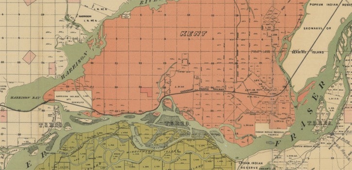
(Editor's Note: The following letter was submitted this week for publication in The Observer, in response to several letters about the Salish Sucker Draft Recovery.)Dear Editor,Your inbox has been crowded with letters from local farmers and politicians who are anxious and angry about the recently released draft Salish Sucker Recovery Strategy. As lead author of the Strategy, a local landowner/taxpayer, and a professional biologist who has studied and worked in local streams for the past decade, I would like to clarify a number of misconceptions about the Strategy and the local waterways.First, there is obviously a great deal of confusion regarding the critical habitat identified in the draft document, which includes areas of farmland in the riparian area(the land adjacent to a waterway). These are not setbacks proposed for expropriation or reforestation. They are simply identified as the area important to the quality of fish habitat in the stream.They are the areas of interest for restoration if landowners are willing and interested. According to DFO, where these areas are farmed currently, farming may continue - as was made very clear at the public consultations. It is my hope that DFO would provide financial incentives, in effect paying farmers for the ecological services that maintaining a natural riparian area provides. Second, there has been a lot of rhetoric claiming that the waterways are 'purpose built' and 'manmade'. There is no doubt that many of the smaller ditches especially in headwater areas were dug by farmers to drain land. The main channels of Mountain Slough, particularly in the area east of west of Sutherland Road, however, are natural, salmon-bearing streams that have been dredged and straightened. A graduate student at UBC recently forwarded me a map she found in the UBC library's Rare Books and Special Collections section. It is a 1905 government map showing the original land survey lines, existing road and rail lines, and the existing waterways. The local road network was limited to the 'wagon trail to Harrison Hotsprings', a couple of cart tracks through the current Agassiz town site, and the CPR. There were no roads whatsoever in the Mountain Slough watershed, yet the map clearly shows the main channels of Mountain Slough, and its major tributaries. The lower reaches of what we know as the McCallum Ditch, the MS1 and the Hogg Ditches are natural streams, although the Ditching and Dyking Committee, led by those who own those very streambanks, loudly claims that they too were dug and should not be considered habitat. Third, the point is being lost that the strategy consultation is the beginning of a process - an opportunity, really - to resolve a serious, longstanding, and divisive issue in our community. As I see it, our goal should be to maintain drainage on agricultural lands without damaging the ability of our creeks and wetlands to provide the ecological services we also need. We need them to support fish and wildlife, to purify our water, to reduce flooding and to conserve our soils among many other things. The next step in this process is the development of an Action plan that we, as a community, can use to achieve this. It is true that DFO's decisions regarding waterway maintenance have been uneven and sometimes illogical. It is also true some farmers exacerbate the problems - leaving stream and ditch banks bare, eroding, and unshaded, while complaining that drainage is impeded by grass that thrives under those very conditions. By moving beyond this impasse working together, the District, local landowners and DFO can develop ways to restore the integrity of our local ecosystem while maintaining drainage. I believe the solution needs to include financial incentives that pay farmers to restore key pieces of land habitat for the ecosystem services they provide - as is done successfully by Delta Farmland Trust, and in nearby Whatcom County, Washington.Our streams and ditches contain what little is left of a thriving, highly productive, valley- bottom ecosystem unique to our corner of the world. Fueled by some of the largest salmon runs in the world, it supported a spectacular abundance and diversity of species that included some very rare fish and frogs. Those species are now sliding towards extinction. They are telling us something.I chose to buy land and live in Agassiz because of its natural beauty, its close sense of community, and its self-sufficiency - which is largely due to the resourcefulness of its farmers and the productivity of its land. Rather than retreat to the same entrenched positions and argument, farmers and especially our community leaders need to take up the partnerships and tools available and use them to find creative solutions that benefit both agriculture and our environment. Sincerely, Mike Pearson, Agassiz