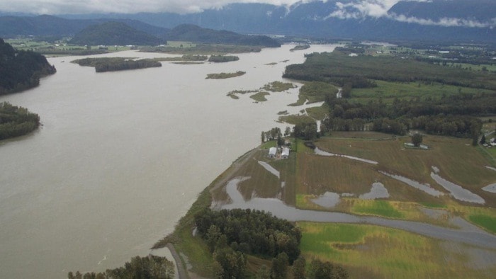
Vast sections of dike that hold back the Fraser River in the event of a major flood are at risk of failing, unleashing a devastating flood that could cause losses of more than $20 billion.
That's the stark warning in a new series of reports and flood maps released Monday by the Fraser Basin Council, which says the region is at risk of suffering the worst natural disaster in Canadian history.
The agency continues to lead a multi-phase initiative to assess and respond to the risks of Fraser River flooding and coastal flooding from storm surges.
Climate change is amplifying both threats, according to Fraser Basin Council senior program manager Steve Litke, because of projections of sea level rise requiring higher dikes to protect coastal areas, and now new forecasts that a flood along the lower Fraser is becoming more likely.
MORE RESOURCES: Fraser Basin Council maps and reports
That increased probability of an "extreme" river flood is due to warmer spring temperatures that can cause a fast melt-off of alpine snowpack, coupled with heavy rains, according to the Lower Mainland Flood Management Strategy report.
"We're not as well protected as we thought we were," Litke said. "Both coastal and river flooding is anticipated to increase in frequency and magnitude going forward."
The aim of the agency is to develop a blueprint for deliberate, planned upgrades starting in 2018 to help avoid a repeat of 2007, when the Fraser threatened to flood and politicians frantically dispatched hundreds of dump trucks to raise dikes as an emergency action.
"We dodged a bullet," council chair Colin Hansen said of that near-flood. "The waters of the Fraser River came within half meter of breaching the dikes that year."
The council's new analysis of current preparedness rated 69 per cent of dikes in the Lower Mainland as fair to poor, 18 per cent as poor to unacceptable, and 13 per cent as fair to good.
Only four per cent of dike segments assessed meet current B.C. standards for dike crest hike, which calls for 0.6 metres of freeboard above the water surface in a repeat of the 1894 flood of record for the Fraser.
Seventy-one per cent of assessed dikes are vulnerable to failure by overtopping in either a major river or coastal flood, consultants found.
Quakes also a dike threat
A large number of dikes aren't just too low, they are also seismically vulnerable, because they were built years ago to outdated earthquake standards. In many cases, underlying soils near the Fraser are vulnerable to liquefaction in a quake, potentially compromising the dike.
Work to improve dikes is expected to be a multi-decade projects with vast costs.
Some flood defense improvements have already been funded by the province but much more is required.
There's no detailed breakdown yet of what sorts of new projects would be required along the Fraser River, or the timeline or cost-sharing mechanisms for getting them built. That's the next phase of work the council is planning.
A 2012 study on the costs of climate change adaptation provided a rough estimate of $9.5 billion in work required to raise or stabilize dikes just to deal with the coastal threat from sea level rise in the Lower Mainland.
Fraser Basin officials admit a key risk is whether or not they can hammer out an agreement among local governments and the province to embark on critical work as quickly as they'd like, particularly in light of intense pressure to fund other infrastructure priorities.
A coordinated regional strategy is needed for any work done because flood water that's pushed back by higher dikes in one area will flow to another.
To dredge or not?
It's not yet clear whether dredging will be one tool used to reduce the ever-increasing amount of gravel in the riverbed, and ease the resulting risk of flood.
"It's a very polarizing issue," Litke said, adding dredging will be examined as a potential option to remove gravel.
"We want to take out what's coming in annually so we maintain the capacity of the river channels," he said, adding the region needs to avoid a scenario where dikes must be raised ever higher.
"But we want to be very careful about how we do that. We don't want to destabilize the river channel. We don't want to create a new problem for any neighbouring community. And we certainly want to be cognizant of the environmental impacts, what's the right timing and location."
What isn't under consideration is any emergency strategy where dikes might be deliberately breached in a high water scenario to allow water onto certain areas of farmland to reduce pressure on dikes elsewhere.
"There's no huge benefit from sacrificing one area to save another," said Neil Peters, B.C.'s former inspector of dikes, who added that would provide only a brief window of relief before the sacrificed area was full of water. "It isn't a strategy that has been considered."
The volume of water moving in the Fraser at flood level is enough to fill seven Olympic swimming pools every second.
To view the Fraser Basin Council flood maps and reports, see floodstrategy.ca.
DEFINING AN EXTREME FLOOD
A flow of 16,500 cubic metres per second flowing in the Fraser River at Hope is currently considered the 1-in-500 year flood, with a 0.2 per cent chance in any given year.
By comparison, the huge flood of 1894 – the Fraser's flood of record – was estimated at 17,000 cubic metres per second.
By the year 2100, as climate change impacts grow, the 1-in-500 year flood could have a peak flow of 19,900 cubic metres per second, an amount now considered a 1-in-5,000 year event.
A major flood today would overtop dikes in multiple areas and inundate nearly 100,000 hectares of land.
Transportation links would be cut off with major highways underwater and food and other supplies could dwindle in as little as four days, according to the new Fraser Basin Council report.
More than 650,000 tonnes of debris would be floating on the floodwaters.
The tide of destruction would bring significant environmental contamination from chemicals, fertilizers, petroleum and raw sewage released by various compromised industries, treatment plants, and hazardous waste storage sites.
The report estimates 690 buildings would be destroyed in such a flood today, and 3,600 would be damaged, with building losses of around $9 billion.
Hospitals, police or fire stations and schools would be among the losses.
An estimated 266,000 people would be displaced and seeking shelter.
A major Fraser River flood today would result in total losses of $22.9 billion, the report estimated, and that could hit $32.7 billion by 2100.
A coastal flood from an ocean storm surge could result in losses of $19.3 billion, climbing to $24.7 billion by the end of the century.