New maps reveal the increasing flood danger to the Fraser Valley as British Columbia’s climate continues to change without any improvements to the region’s diking system.
The Fraser Basin Council has produced maps illustrating three different flood scenarios.
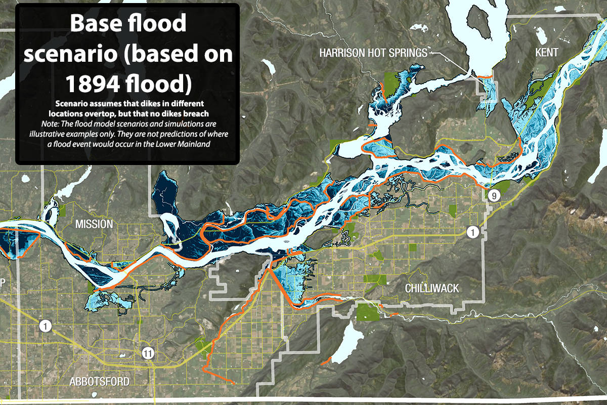
The first simulated a flood like that which occurred in 1894. Were such a flood to occur today, all eyes would be on the region’s diking system, which is seismically suspect and has been judged to be insufficient in many areas.
The deepest floodwaters would swamp the north and east of Hatzic Lake, in and around Dewdney and Deroche on the north side of the Fraser River, and the Glen Valley in northwest Abbotsford and northeast Langley, where many areas could see flood waters rise three metres or more above ground.
Although the maps released by the Fraser Basin Council are accompanied by a disclaimer saying they shouldn’t be treated as exactly where flooding will take place, they are based on extensive modelling and records of the region’s dikes.
Harrison Hot Springs, including its commercial core, could also end up flooded. The same fate could befall much of Greendale in west Chilliwack and large portions of the Skwah First Nations reserve north of Chilliwack, as well as the western portion of Matsqui Prairie in Abbotsford.
But as time goes by, and the climate changes, the potential scale of a big flood is expected to increase, the map shows.
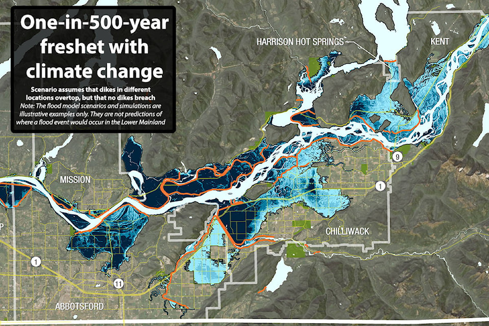
The 1894 flood has been pegged at a one-in-500-year event. But as time goes on, a flood of that size has become more likely. Meanwhile, the scale of a true one-in-500-year disaster has grown significantly and will continue to do so.
Rising sea levels aren’t expected to have too much of an impact on flooding in the eastern Fraser Valley, and snowpacks are likely to be smaller. But as the climate changes, it is expected that the snow that does exist will melt much more rapidly. More precipitation is also expected during large rain events, and those two factors could significantly boost the scale of a freshet, according to Fraser Basin Council senior program manager Steve Litke.
By 2050, a one-in-500-year flood will pose a huge risk to most of Chilliwack north of Knight Road, all of Agassiz and Harrison Hot Springs, the entirety of Matsqui Prairie including Matsqui Village, and parts of Sumas Prairie. That is with the flood waters overtopping, but breaching, the region’s dikes.
(Move the slider to see how the outcome of a flood changes based on climate change)
But officials say the region’s dikes can’t be expected to hold in all areas. Breaches are likely before dikes are overtopped, Litke said. That can happen through simple erosion, but also because previously dry dikes that are suddenly immediately adjacent to water can become saturated and collapse. Their stability can also be undermined by water that begins to “pipe” through them.
Ideally, Litke said, dikes would be built two feet higher than the water level planned for. That’s not the case, though, across the Fraser Valley – as illustrated by the map showing the dramatic flooding the region would face by the simple overtopping of dikes.
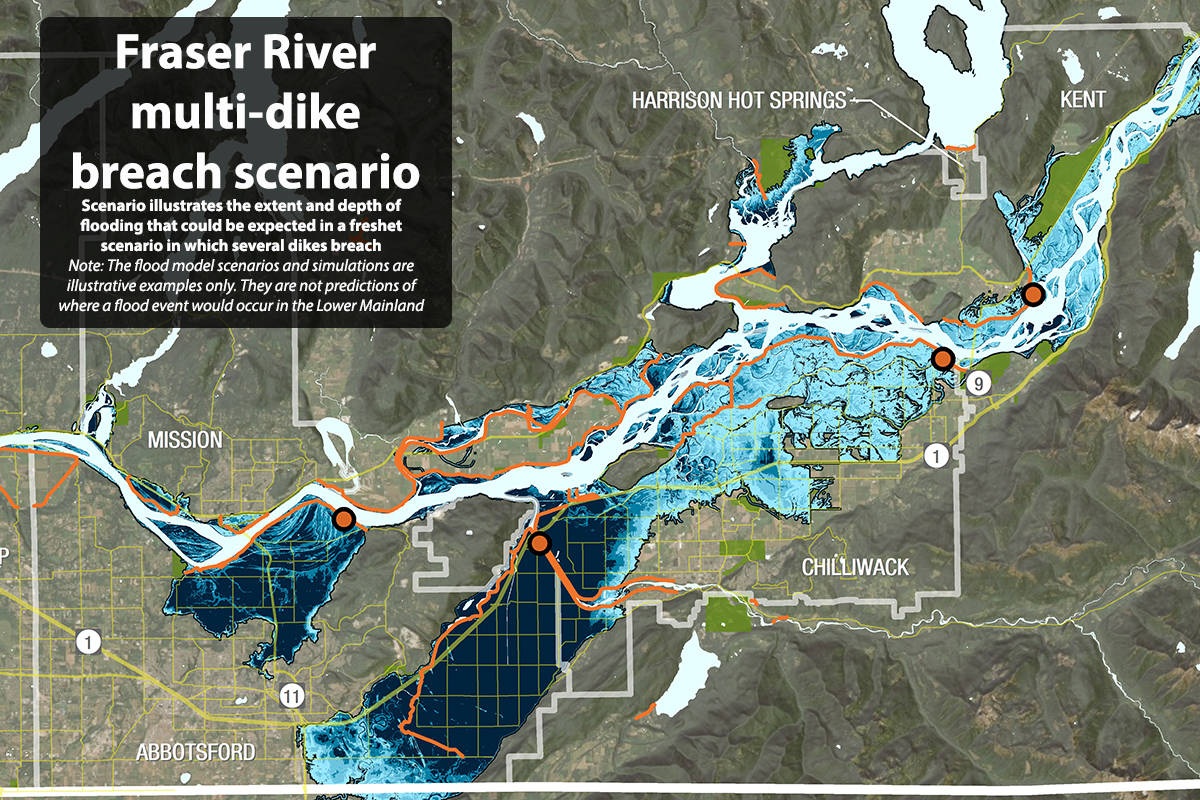
A third map considered an 1894-level flood (i.e. one with Fraser River water levels below a one-in-500-year climate-change event), but with a breaching of dikes.
A breach of the Vedder Canal and Matsqui Prairie dikes would leave all of Matsqui and Sumas prairies under floodwaters that, in most places, would be more than three metres deep.
And although Abbotsford’s commercial core would be safe, the same couldn’t be said for Chilliwack’s. The Fraser Basin modelling imagines a dike breach near the Rosedale-Mission Bridge. Were that to occur, floodwaters could leave much of urban Chilliwack under water – including almost all of downtown as well as much of Sardis north of South Sumas Road. Rosedale and parts of Agassiz would also be under water.